Contents
The oscillation of precipitations
The oscillation of precipitation, which is related to the thermal anomalies resulting from the resonance of oceanic baroclinic waves, is recognizable by its large amplitude in the characteristic bands of the periods 1/2, 4 and 8 years with a low amplitude of the annual oscillation. Resulting from depressions formed or guided by thermal anomalies, rainfall in the impacted areas is distributed evenly between seasons due to the moderator effect of the oceans. Indeed, the thermal anomalies produced by annual waves reach their maximum during the boreal / austral winter.
On the other hand, precipitation that is not related to thermal anomalies resulting from the resonance of oceanic baroclinic waves has a high seasonality, whether due to tropical cyclones, tropical and extra-tropical depressions or monsoon, i.e. seasonal changes in atmospheric circulation and precipitation associated with the asymmetric heating of land and sea.
The dynamic of sea surface temperature anomalies and the oscillation of rainfall in a characteristic frequency band reveals the mechanisms leading to atmospheric baroclinic instabilities and the formation of high and low pressure systems to cause oscillation of precipitation. In particular, precipitation analysis in the 5-10 year band allows for an unambiguous causal relationship because sea surface temperature anomalies of 8-year period are well identified, resulting from the highest baroclinic mode in the three tropical oceans, while not being sensitive to ENSO. In addition, the 8-year period is close to the time required to balance the oceanic and terrestrial thermal anomalies of the perturbed state, which reduces their phase shift.

This analysis highlights regions rapidly impacted by thermal anomalies of oceanic origin where baroclinic instabilities of the atmosphere are preferentially generated. These baroclinic instabilities are most active when the resulting systems of high or low pressure are stimulated and guided by the jet-streams, these ribbons along a winding path through which flows from west to east a strong and rapid airflow at high altitude. The strongest are the polar jet-streams, around latitude 60°, while the subtropical jet-streams are located between 20° and 40° latitude, which explains the key role of subtropical gyres on climate variability.
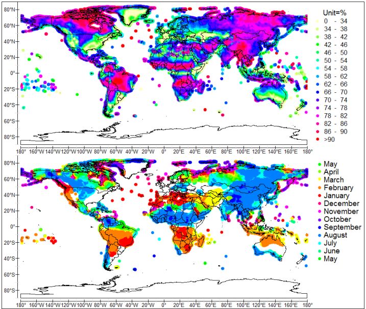
Since the average annual rainfall height is not relevant in our analysis, rainfall is reduced, i.e. divided by the mean rainfall height. Being dimensionless, the temporal variations of reduced rainfall are homogenized this way on global scale and a causal relationship can be established between sea surface temperature and rainfall anomalies. The amplitude of reduced rainfall anomalies highlights areas primarily impacted by oceanic thermal anomalies. Phase allows to discern transfer mechanisms.
The main areas subject to rainfall oscillation, that is to say those that warm or cool at first, are a) The south-west of North America, b) Texas, c) The south-east of North America, d) The north-east of North America, e) The southern Greenland, f) Europe and Central and Western Asia, g) Region of the Río de la Plata, h) Southwestern and southeastern Australia, i) The Southeast Asia.
Regions subject to rainfall oscillations in the 5-10 yr band (Pinault, 2018a)
The videos simultaneously show the sea surface temperature anomalies on the left and rainfall anomalies on the right for different periods of 8 years. For each region of the globe concerned, 2 videos systemically represent periods of high and low activity. In all cases the phase is expressed relative to the signal -SOI (Southern Oscillation Index).
The impact on climate of these sea surface temperature anomalies, which either stimulate or, on the contrary, reduce evaporation, is substantial because they generate baroclinic instabilities that may lead to the formation of cyclonic or, on the contrary, anticyclonic systems of the atmosphere. The latent heat flux withdrawn from the oceans is transferred to the continents during rain events that result from the condensation of water vapor.
The highlighting of interactions between sea surface temperature anomalies and the system of continental precipitation is performed using the band of periods 5-10 years because of the ubiquity of thermal anomalies: they are the result of a baroclinic mode involving oscillation of the interface at the top of the pycnocline in tropical oceans, of mean period 8 years. On the other hand the oscillation of precipitation in the same band is insensitive to El Niño and reflects a causal relationship with ocean unambiguously. The following analysis thus refers to short periods. It nevertheless has an intrinsic interest for long periods because primarily impacted regions remain the same, even if the interactions between oceans and continents are more global because of the involvement of the gyre in full: thermal anomalies at mid-latitudes remain very active due to the jet-streams.
a) North America
Three regions are mainly impacted, California, the Mississippi and Louisiana states, and finally the eastern most tip straddling the Labrador and the Appalachians, and Newfoundland. The oscillation phenomena in the band 5-10 years are directly linked to ocean temperature anomalies resulting from gyral Rossby waves in the North Pacific and North Atlantic, in the same band.


In the south-west of North America, rainfall oscillation in the band 5-10 years is linked to the temperature anomaly along the western coast of North America, which comes from the eastern antinode of period 8 years in the North Pacific, after it has drifted eastward in the absence of thermohaline circulation. Rainfall and temperature anomalies are almost in phase, so that the mechanisms involved in the oscillation of precipitation are connected to the subtropical jet-stream. A positive oceanic thermal anomaly favors the formation of extra-tropical cyclones not only because of the high temperature, but also the high dew point gradient between the center of the anomaly and its periphery. Extra-tropical cyclones follow the subtropical jet-stream along the parallel 35°N, by pouring abundant rainfall in the southwest of North America, where « cut-off lows » are primarily formed in California and in western Nevada, cold lows in deadlock due to the barrier of the Rockies. In contrast, negative oceanic thermal anomaly favors high pressures and anticyclones, forcing the subtropical jet-stream to move south of the thermal anomaly in describing a large meander. Southwestern North America suffers from drought.
In Texas rainfall oscillation is linked to the thermal anomaly that stretches around the subtropical gyre of the Baja California Peninsula. The mechanisms involved are similar to those raised in California.
In the south-east of North America, the rainfall anomaly is in phase with the sea surface temperature anomaly off the Cape Hatteras formed by the western antinode of the 8-yr period quasi-stationary wave of the North Atlantic gyre. The strengthening of precipitations is related to the amplitude of the SST anomaly. This means that a positive thermal anomaly favors the movement of tropical cyclones from the Gulf of Mexico and the Caribbean Sea to the north due to the merger of two low pressure systems formed firstly from tropical depression secondly the extra-tropical depression resulting from the thermal anomaly. Some tropical cyclones make landfall, hence the increase in precipitations in Louisiana, Mississippi, Alabama, Arkansas and Tennessee. Particularly affected are the states of Mississippi and Louisiana when tropical depressions become hurricanes.
This coupling disappears when the thermal anomaly becomes negative, which favors the formation of anticyclones at the northwest Atlantic. These anticyclones are blocked where the « cut-off highs » are formed, warm areas of high pressure move north of the subtropical jet-stream, as occurs commonly in the south-eastern United States during the summer.
Rainfall oscillation northeast of North America is closely related to the oceanic thermal anomaly at the eastern antinode of the gyral Rossby wave in the North Atlantic. The coupling has occurred particularly during periods 1938-1953 and 1978-2001. Extra-tropical depressions formed over the positive thermal anomaly due to the rise in temperature and in the dew point gradient, induce an increase in precipitation in north-eastern North America. In contrast, anticyclonic conditions prevailing when the thermal anomaly becomes negative induce a decrease in rainfall.
Rainfall oscillation is reduced when the ocean temperature anomalies are vanishing as is the case during the period 1962-1969.
b) The southern Greenland
South of 70°N, the tip of Greenland is subject to oscillation of rainfall in phase opposition with the thermal anomaly associated with the eastern antinode of the North Atlantic, at the entrance of the Davis Strait. By blocking the flow of the polar jet-stream, a negative thermal anomaly induces a positive rainfall anomaly because the depression and the jet-stream are diverted north to avoid the area of high pressure, causing an increase in snowfall. However, when the thermal anomaly is positive, the polar jet-stream is reinforced by the resulting low pressure system, which promotes the flow of warm and dry air masses in southern Greenland. Note that this phenomenon also occurs along the Aleutian Islands, Alaska.
c) Europe, Northwestern Africa and Central and Western Asia
Europe, Northwestern Africa and Central and Western Asia are particularly subject to the oscillation of rainfall in the band 5-10 years at latitudes above the horse latitudes between 30 and 35°N. The deep continental penetration of the precipitation oscillation phenomenon demonstrates the alternation of high and low pressure systems stimulated and guided by the polar jet-stream. Indeed, in the North Atlantic extra-tropical cyclones and anticyclones are formed from thermal anomalies of 4 and above all 8-year periods. The migration of depressions across Europe to Asia benefits of a low relief north of the Alps and the Himalayas.
The pattern of surface temperature anomalies in the North Atlantic reflects western and eastern antinodes. Off the Cape Hatteras, their magnitude is controlled by the long-period gyral Rossby waves as a result of coupling between harmonics (Pinault, 2012). Thus the amplitude of SST anomalies may vary largely. It determines the amplitude and phase of the oscillation of precipitation in Europe, Northwestern Africa and western and central Asia, north of latitude 30°N, extending east to 85°E. Five areas are particularly impacted, northwestern and Western Europe, states located around the Black Sea, Uzbekistan and Kazakhstan and finally Morocco and Northern Algeria.
The oscillation of precipitations disappears with oceanic thermal anomaly, as this occured from 1954 to 1985 when the amplitude of anomalies in the band 5-10 years remains below 10%. In the absence of significant thermal anomalies, extra-tropical cyclones and anticyclones lose their anchorage and are produced more uniformly in space and time. Therefore, rainfall is evenly distributed during 8-year cycles.
Outside this period of very weak anomalies, the oscillation changes as a function of the extension of the sea surface temperature anomalies and the differentiation of the phases between the anomalies. Comparing the phases of thermal and rainfall anomalies reveals the origin of extra-tropical cyclones causing precipitation, which depends on the cycle. This means that the trajectory of the polar jet-stream is closely dependent on the configuration of the thermal anomaly.
The rainfall oscillation occurs in Uzbekistan and Kazakhstan as soon as the thermal anomalies linked to the resonance of baroclinic waves in the North Atlantic have sufficient amplitude, because all parts of the anomaly can potentially produce low or high pressure systems guided by the polar jet-stream, which induce heavy rainfall or drought in the north of the Himalayas, these systems being blocked by the relief. However, the oscillation of precipitation in Western Europe reaches high amplitudes if the phases of the thermal anomalies are well differentiated. In this case mainly the westernmost part of the western antinode is involved. Rainfall anomalies in phase opposition may appear in northwest Europe on the one hand and Western Europe and Northwestern Africa on the other hand, as a wealth of literature calls the North Atlantic Oscillation (NAO+ and NAO- depending on the sign of temperature anomalies of the dipole) that reflects a pressure difference between the Azores High and the Icelandic Low.
d) Region of the Río de la Plata
The rainfall anomaly is in phase with the thermal anomaly that extends eastward between 20°S and 40°S in the South Atlantic. Positive thermal anomaly at the western antinode promotes upper-level trough in phase with a low-level warm-core low. Subtropical cyclones may form if a strong dipole-blocking structure persists over the thermal anomaly, which decreases wind shear across the region. Then, a low pressure area develops over the Amazon basin, and intensifies as it moves south-eastward or eastward over open waters, establishing a very large closed circulation. The main regions exposed to locally heavy rains are southern Brazil (Río Grande do Sul), Uruguay and north-eastern Argentina. In contrast, a negative surface temperature anomaly promotes anticyclonic blocks over the Amazon basin, causing dryer conditions in Uruguay and north-eastern Argentina mainly during austral winter.
e) Western and southern central Australia
Both west and east of central Australia are subject to severe oscillation of precipitation, making them a particularly arid region due to the low average rainfall height. The main rainfall anomaly is in phase with the thermal surface anomaly west of Australia, which is usually of low amplitude. This thermal anomaly results from the recirculation through the South Indian subtropical gyre of the warm/cool mixed layer resulting from the resonance of short period oceanic Rossby waves in the vicinity of the southern tip of the continental shelf of Africa. These particular sea surface temperature anomalies are subject to a large variability due to their coupling with long-period sub-harmonics.
Located between 90°E and the western coast of Australia and between 20°S and 40°S in latitude, the thermal anomaly never exceeds 0.25°C. However, stretching along the subtropical jet-stream, it is extremely active and produces strong westward positive or negative rainfall anomalies.
Thus, lows produced upright positive thermal anomalies west of Australia are pulled towards cut-off lows. The same mechanisms are involved in the motion of highs produced upright negative oceanic thermal anomalies. Concerning rainfall anomalies over the Western Australia, cut-off lows and cut-off highs are formed against Musgrave Ranges, a mountain range in Central Australia extending into Western Australia, as well as the MacDonnell Ranges, a series of mountain ranges located in the center of Australia. As for rainfall anomalies over the south-eastern portion of the continent, cut-off lows and cut-off highs are formed against the East Australian Cordillera.
f) The Southeast Asia
Although exhibiting lower multiyear rainfall anomalies, south-east Asia is subject to north-eastward migration of tropical cyclones as occurs in south-eastern North America. Here, positive rainfall anomalies in the western tropical Pacific seem less decisive for moving of tropical cyclones to the north by merging two low pressure systems.
Glossary
The horse latitudes, between 30 and 35°N or S, define an area highs, the quiet zone created by the subtropical descending column of the Hadley cell. It is said that the term comes from the days when Spanish sailing vessels transported horses to the West Indies. In the absence of wind in these latitudes prolongation of trip resulted in shortages of food and water and the crews were sometimes forced to throw horses overboard or kill them to prevent starvation on board.
The dew point or dew temperature is the lowest temperature at which an air mass may be subjected, with fixed pressure and moisture, without the occurrence of a water liquid formed by saturation.
SOI (Southern Oscillation Index). The SOI is the amplitude of the Southern Oscillation; it is a measure of the monthly change in the normalized atmospheric pressure difference at sea level between Tahiti and Darwin (Australia).
Jet-streams are fast winds aloft blowing from west to east. Along a curved and sinuous path, they play a major role in atmospheric circulation as they participate in the formation of depressions and anticyclones at middle latitudes, which then move under these powerful atmospheric currents.
Baroclinic instability draws energy from the portion of the potential energy available to be converted. Available potential energy is dependent upon a horizontal gradient of temperature. The conversions of energy are proportional to perturbation heat fluxes in the horizontal and vertical that, as part of this article, are related to oceanic thermal anomalies resulting from the resonance of baroclinic waves. A horizontal temperature gradient implies the presence of vertical shear. So, baroclinic instability is also an instability of the vertical shear.